|
Utility Locators Orange County
Water Leak Shuts Down Sunset In Beverly Hills, Prompts Water Conservation Warning-D
Non-Destructive Testing Superior Leak Detection Pinpoint Leak For The City Of Beverly Hills Water Main Break December 17, 2018
Utility & Underground Services Location
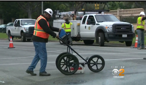
Underground services surveys are an important aspect of any site construction work. Most underground services can be detected using electromagnetic detection equipment which can normally determine depth and measurements for cables, metal pipes and drainage runs. However some non-conductive services, for example, fibre optic cables and plastic pipes, require more specialist equipment such as GPR (Utility Locating. .The latest electromagnetic service or ground radar locators are used to determine the position of most underground cables and pipes. All routes are site marked with biologically degradable paint. Drains can be located using electronic sondes emitting a signal from the pipe, which is then located on the surface. All this information can then be surveyed to provide a comprehensive record of on site services and depths.Our surveyors are fully conversant with health and safety procedures regarding entry into confined spaces. These procedures will always be used when required.Surveys will be undertaken to TSA Utility Guidance Note Standards.
o
Utility Utility Locating survey equipment, we are able to provide an accurate survey of underground features and utilities. By sweeping the required area on a grid system, the surveyor is able to see images on a screen, which is a cross section through the ground. The evidence of items such as disturbed soil, voids and foreign objects (i.e. pipes, tanks, foundations etc.) can then be interpreted and cross-reference to their relevant ground locations, either immediately on site (‘mark to ground’) and / or on CAD. Items that are usually detectable; In general, Leak & Utility Surveying Services undertake to survey only for declared services (i.e., services that appear on statutory record drawings). We will of course Pinpoint to locate and track any services not featured on records. If required and where possible depth estimations will be supplied. Services included in an Electromagnetic Survey;
|
.png)
.png)

|

Concrete Imaging (Including Rebar Mapping)
Concrete Floor Slab Surveys
GPS Utility Surveys
GPS Mobile Leak Detection Surveys
Electromagnetic Induction
GPS Electro Magnetic Utility Locating
GPS Underground X-Ray Mapping
GPS Underground Utility Surveys
Ground Penetrating Radar GPR
GPS Septic Tanks Location
GPS Utility Locating
GPS Tank Location
Thermal Imaging Leak Surveys
GPS Building Investigation
Forensic Support
Golf Course Mapping
GPS Cemetery Mapping
GPR Military Support
· Water Distribution Leak Surveys · Water Treatment Plant Surveys · Municipal Water Loss Audits · Private Water Systems Leak Surveys · Sewer Leak Surveys & Sewer Line Location
· Commercial Utility Location Surveys · Ground Penetrating Radar Services · Commercial Water Leak Detection
·
Military Leak Surveys
· Natural Gas Leak Surveys · Video Camera Pipeline Inspection Surveys
· Combustible Gas Leak Surveys · Plant Leak Survey
Underground Utility Color Chart
|

|

.png)
.png)
.png)